
Usually, Manipur faces flood situation when rainfall rate in catchment areas reaches 30 mm but the rainfall rate recorded this year in catchment areas reached 78 mm.
Some main functions of Irrigation and Flood Control Department (IFCD) are looking after main rivers of the State and their tributaries and checking breaching of river embankments .
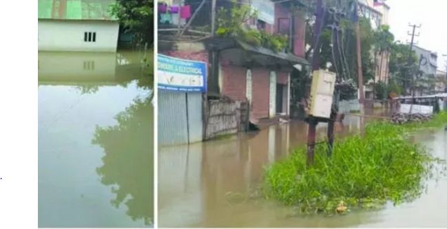
Yet, IFCD is currently engaged in pumping out water collected at Lamphelpat including Langol through Naoremthong Samushang Uku.
Altogether eight electric and diesel generators are pressed into operation on rotational basis, sources informed .
Moreover, Naga rivulet and Chandranadi canal are being dredged regularly .
But the department has no plan, as of now, to pump out water from other places which have been inundated.
The work of pumping out water is the responsibility of respective district administration, said the IFCD sources .
As of now many localities in Imphal are reeling under flood water, especially Lamphel, the road leading to Shija Hospital, Nagaram and the adjoining areas etc .
As such, the flooded areas are unlikely to become dry unless the water levels of major rivers recede dramatically and water flooding human settlement areas are drained out through natural drainage system .
Moreover, the department has no plan to take up any de-clogging exercise.
At the moment, IFCD is focusing its efforts on repairing vulnerable river banks, filling holes along river banks where water is leaking and ensuring no further breaching of river embankments, informed the sources .
In spite of retaining walls, there have been places where water is leaking beneath the earth’s surface.
The department has been working to plug these holes.
Nonetheless, the department is prepared to provide necessary flood fighting materials if there is overflow of water or breaching of river bank .
Even though the department has enough stock of bamboo thatches, there is no abundant stock of empty cement bags .
The total length of Iril River, Imphal River, Nambul River and some other rivers may be around 1000 Kms but only 5 per cent of their total courses have retaining walls .
There are many places where these rivers need retaining walls but retaining walls could not be constructed due to financial constraints .
Even though it would be impossible to construct retaining walls all along the river courses, many portions of river banks are quite vulnerable to strong water currents .
This season’s rainfall is the highest and the resultant flood is the severest during the past 20 years in Manipur .
As the water volumes are quite huge, rivers were overflowing at different places but large scale devastation was averted with the help of people living at these places, said the sources.
Rainfall rate reached 78 mm at Kangpokpi which is one of the catchment areas of Imphal River.
With rain continuously lashing the area, water absorption capacity of the surrounding lands has saturated thereby aggravating the flood situation .
Even though Imphal River falls into Manipur River, Manipur River cannot drain out water from Imphal River as the water levels of both Khuga River and Chakpi River remain quite high which too fall in Manipur River .
It is feared that most parts of Manipur valley would be flooded if the present situation persist for the next 10 days or so, the sources informed .
At the moment, four gates of Ithai Barrage are open while all the five gates of Imphal Barrage are open .
Concept paper has been prepared after identifying vulnerable sections of Imphal River and Kongba River banks for strengthening them.
The State Cabinet has given its consent to hire a consultant through restricted tender .
If the Government of India approves the project, necessary steps would be taken up to get it started, the sources said .
According to a satellite data issued by the Manipur Remote Sensing and Application Centre, 11.46 per cent of the total land area of Imphal West, Imphal East, Bishnupur, Thoubal and Kakching have been inundated .
Altogether 22,356.69 hectares have been inundated with Imphal East being the worst affected .
According to the satellite data taken on July 7, 16.75 per cent of the land area of Imphal East and 16.32 per cent of Thoubal district’s land area have been inundated.
Source: The Sangai Express


