 Guwahati, September 20 2017: Officials in two of the four North Eastern States bordering Myanmar have said they are wary of a free movement agreement between the two countries that could burden them with Rohingya refugees, who have fled fearing persecution.
India and Myanmar have a decades-old free movement regime (FMR) that allows ethnic communities living on either side of the border to travel 16 km across the boundary without a visa.
Some 300,000 people living in more than 250 villages within this zone keep crossing the border often through 150 formal and informal border crossings .
Mizoram shares a 510-km border with Myanmar.
The other border-States north of Mizoram are Manipur (398 km border), Nagaland (215 km), and Arunachal Pradesh (520 km) .
Large hilly swathes of Myanmar’s Chin State separate Mizoram from Rakhine.
Chin State is dominated by the Chin or Zomi people, ethnically related to the Mizos of Mizoram .
New Delhi has instructed Assam Rifles, the paramilitary force entrusted with guarding the 1643 km long India-Myanmar border, to intensify vigil in view of the possibility of Rohingya Muslim refugees and militants sneaking in .
The alert is specifically for Mizoram’s Lawngtlai district, which on the map is closest to Myanmar’s troubled Rakhine State from where the Rohingyas are fleeing .
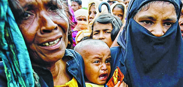
Nearly 420,000 Rohingya Muslims have fled Arakan in Myanmar’s Rakhine State after Rohingya insurgents attacked police posts.
Myanmar’s military retaliated with “clearance operations” to root out the rebels but the fleeing Rohingyas say soldiers shot indiscriminately, burned their homes and warned them to leave or die .
Officials in Mizoram said the alert along the Myanmar border in view of the Rohingya crisis could be a routine drill .
“The ethnic cousins of Mizos in Myanmar do visit their relatives on this side of the border, but it is geographically unlikely for Rohingyas to cross over,” Mizoram’s Home Minister Larzirliana said.
The sea route or relatively less hostile terrain along Myanmar’s border with Bangladesh is more convenient for the Rohingyas to flee.
If at all they move inward, it would be easier for them to travel 746 km from Rakhine to Moreh (Manipur-Myanmar border) via the Monywa-Kalewa highway, officials said .
This is precisely the reason why Manipur was the first State on the Myanmar border to sound an alert for a possible influx of Rohingya refugees .
Officials in Mizoram said a few recent cases of migration of Myanmar border villagers into India night have influenced Delhi in sounding the alert.
Last month, some 200 Christians from Rakhine crossed over to escape clashes between the Myanmar army and armed militant group Arakan Rohingya Salvation Army.
A similar incident happened in May when another insurgent outfit in Myanmar’s Chin state forced some 300 people to shift temporarily to southern Mizoram’s Siaha district.
Besides, there are an estimated 60,000 Chin refugees in Mizoram and Manipur .
“Steep hills, dense jungles and fast-flowing streams make manning the border difficult with certain stretches almost impossible to cover.
North East militants thus sneak in for attacks and slip right back into their bases in Myanmar.
It is not difficult for local people accustomed to this terrain to do the same,” an Assam Rifles officer said .
“We cannot stop Myanmar Nationals from coming in within 16 km of the border for trade or catching up with relatives and acquaintances in India because of FMR.
This has made checking infiltration all the more difficult,” he added.
Source: The Sangai Express/Hindustan Times


